Arequipa
Arequipa is Peru’s second largest city with a population of 826,859 people. Although sitting in a valley, the elevation is still quite high. Three snow-capped volcanoes, Misti, Chanchani, and Pichu Pichu, dominate the city’s panorama. Of the three, only Misti remains active. Inhabitants of this city are involved in industrial and commercial production, including camelid wool products. The historic center of Arequipa spans an area of 332 hectares and is a UNESCO World Heritage Site. Arequipa is called the "White City" because many of its buildings are made of white volcanic rock called sillar.
The city has a large number of public and private health centers, however urban slum conditions mean that many still live with a lack of access to basic services. “Pueblos Jovenes” (permanent squatter communities) completely ring the city. In these communities, health care is not universally available and is often substandard. Many Peruvians living in “pueblos jovenes” are forced to resort to traditional remedies rather than seeking medical treatment.
* Project Description: These projects provide medical, dental, physical therapy and optometry services and equipment in the communities of Arequipa city, Pedregal, Lahoya, and Camana. We will work in partnership with local churches and social organizations serving in Arequipa. The team will consist of MMI volunteers from North America, local Peruvian volunteers, and MMI-Peru staff and in collaboration with the local municipalities. The clinic site locations will be a variety of church buildings, community centers, health facilities and public parks.
Elevation
2328 m (7638 ft.)
Climate
Warm and dry.
Days are warm, while nights and early mornings are cold.
Dressing in layers is recommended.

Ayacucho
Ayacucho is the capital city of Huamanga Province, Ayacucho Region. It is a relaxed, small town of colonial style with approximately 32,000 citizens, complete with old streets full of charm. Ayacucho is 558 km from Lima (the capital city of Peru). Ayacucho was the capital of the last pre-Inca Empire and is located in the middle of the driest area of Peru. It was founded in 1539 by Francisco Pizarro. Now it is famous because of the religious celebrations that take place.
The inhabitants of Ayacucho are involved in agriculture and light manufacturing of textiles, pottery, leather goods, and filigree wear. Ayacucho is famous for its 33 churches, each representing one year of Jesus' life. It was a key site for a major battle for Peruvian independence from the Spanish. There is a tradition in the city that all houses must present a little church on the roof of the house.
* Project Description: These project teams provide Medical/Dental/Primary Care or Physical therapy to patients in the city and some rural communities outside of Ayacucho. These projects are done with local Peruvian volunteers and in collaboration with the local municipalities and other associates.
Elevation
2746 m (9007 ft.)
Climate
Warm and dry.
Days are warm, while nights and early morning are cold.
Dressing in layers is recommended.

Camaná
Camaná is a coastal town and the district capital of the Camaná province, 180 km from Arequipa. The population in 2015 was roughly 40,000.
* Project Description: The teams will stay in the coastal town of Camaná and will work in surrounding areas. The team sets up clinic at different sites around Camaná, and the location for clinic sites vary between church buildings, community centers, health facilities, and public parks. The services provided are medical, dental, physical therapy, and optometry. Most of the recipients of our medical services in this area are farmers. We work in partnership with local churches and social organizations serving in the area. The team will consist of MMI volunteers from North America, local Peruvian volunteers, and MMI Peru staff.
Elevation
15 m (49 ft)
Climate
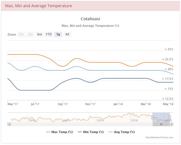
Camaná is considered to have a desert climate. During the year, there is virtually no rainfall. The average temperature in Camaná is 20.0 °C. The average annual rainfall is 1 mm.
Colca Valley
The Colca Valley is found in the Andean mountains and is one of the most spectacular landscapes in the world. In fact, outside of the Himalayas, it is impossible to find more peaks over 20,000 feet in such a concentrated location. “The Valley of the Fire” and “The Kingdom of the Condor” are a couple of the many titles given to the Colca Valley, whose river has carved out a dizzying canyon in a geographic fault that plunges down to 3,400 m in depth (twice as deep as the Grand Canyon) and runs for more than 200 km in total. The valley has been inhabited since pre-Inca times.
One of the major attractions of the area (which led the famous Peruvian writer Mario Vargas Llosa to call it the "valley of wonders”) is the truly amazing terracing that crisscrosses the landscape. The Colca Valley terracing is considered among the most extensive in southern Peru. These works, which allow cultivation and meticulously controlled irrigation of the steep slopes of the canyon, were built by indigenous groups between the 9th and 14th centuries AD. Today, the inhabitants of the Colca Valley continue to use some of the same terraces of their ancestors for the cultivation of corn, potatoes, broad beans, alfalfa, quinoa, barley, and wheat. The traditional clothing is still worn by the majority of women in the Colca Valley.
* Project Description: The teams serve in several different districts of Colca Valley working in partnership with local communities. The teams set up mobile clinics with a triage area, consultation rooms, dental area, eye examination area, physical therapy area, pharmacy, and health education area. The conditions of the facilities where we set up clinic are very simple and basic. Many of the patients we see do not receive regular medical and dental care, so all kinds of health problems will be encountered. Common complaints include gastritis, arthritis pain, lower back pain, skin problems, respiratory problems, diarrhea, and dehydration. The Integrated Health component of these projects include discussions about hygiene, preventing the spread of germs, dental health, preventing dehydration, and more.
Extreme Project: An "extreme" project requires participants to be physically prepared and willing to do long hikes at high elevation. Accomodations and facilites for clinic are very rustic.
Peru Extreme Packing Suggestions
Elevation
11,000ft/3,400m
Climate
Warm and dry. A similar climate to Arequipa is experienced.
Days are warm, while nights and early morning are cold.
Dressing in layers is recommended.

Cotahuasi
Cotahuasi is a town in Southern Peru, capital of the province La Unión in the region of Arequipa. The Cotahuasi Canyon is one of the deepest canyons in the world. It is formed by the Cotahuasi River, arising at more than 4,750 m (15,580 ft) ASL in the lake Wansuqucha.
Extreme Project: An "extreme" project requires participants to be physically prepared and willing to do long hikes at high elevation. Accomodations and facilites for clinic are very rustic.
Peru Extreme Packing Suggestions
Elevation
2,683 m
Climate
Warm and dry. A similar climate to Arequipa is experienced.
Days are warm, while nights and early morning are cold.
Dressing in layers is recommended.

Cusco
Cusco, the capital city of the Cusco Province in south-eastern Peru, has a population of 435,114 people. A large proportion of the population is indigenous. Cusco is known as the "Heart of the Inca Empire" and is the archaeological capital of the Americas. The famous Inca Citadel Machu Picchu and the Sacred Valley of the Incas are located nearby and was declared a World Heritage Site in 1983 by UNESCO. Tourism represents a very important source of revenue to the area. However, most inhabitants of this area are involved in agriculture and brewery. The economic benefits from tourism have failed to reach the majority of the population and so many of Cusco’s residents live in poverty.
* Project Description: We provide
medical, dental, optometry, and physical therapy services on these projects. The facilities for clinics are very basic, usually churches or community center buildings. These sites are mostly located outside of Cusco city. The Integrated Health component of these projects include discussions about hygiene, preventing the spread of germs, dental health, preventing dehydration, and more.
Elevation
3400 m (11,200 ft.)
Climate
Dry and temperate.
Dry season: April - October. Sunny and cold.
Wet season: November - March. Wet and cold.

Cusco (Extreme project)
Cusco, the capital city of the Cusco Province in south-eastern Peru, has a population of 435,114 people. A large proportion of the population is indigenous. Cusco is known as the "Heart of the Inca Empire" and is the archaeological capital of the Americas. The famous Inca Citadel Machu Picchu and the Sacred Valley of the Incas are located nearby and was declared a World Heritage Site in 1983 by UNESCO. Tourism represents a very important source of revenue to the area. However, most inhabitants of this area are involved in agriculture and brewery. The economic benefits from tourism have failed to reach the majority of the population and so many of Cusco’s residents live in poverty.
Project Description: An "extreme" project requires participants to be physically prepared and willing to do long hikes at high elevation. Accomodations and facilites for clinic are very rustic.
We provide medical, dental, optometry, and physical therapy services on these projects. The facilities for clinics are very basic, usually churches or community center buildings. These sites are mostly located outside of Cusco city. The Integrated Health component of these projects include discussions about hygiene, preventing the spread of germs, dental health, preventing dehydration, and more.
CLICK HERE for Peru Extreme Packing Suggestions
Elevation
3400 m (11,200 ft.)
Climate
Dry and temperate.
Dry season: April - October. Sunny and cold.
Wet season: November - March. Wet and cold.

Ica
The city of Ica is the capital of the Ica Region in southern Peru. As of 2005, it had an estimated population of over 219,856. The city suffered extensive damage and loss of life during the 2007 Peru earthquake.
The city is located on the Ica River about 300 km to the south of Lima, along the desert coast of southern Peru. Further south along the Pan-American Highway lies the city of Nazca. Ica can be reached from Lima by the Pan-American Highway. The distance is almost exactly 200 miles or 300 km. The trip takes about 4.5 hours by bus and 4 hours on motorcycle.
* Project Description: The team provides medical, dental, and optometry services to patients in the City of Ica. The teams work alongside local associations and churches.
Elevation
406 m (1,332 ft)
Climate
Dry and hot/warm desert.

Lima
Lima is the capital and the largest city of Peru. It is located in the central coastal part of the country, overlooking the Pacific Ocean. Together with the seaport of Callao, it forms a contiguous urban area known as the Lima Metropolitan Area. With a population of almost 10 million, Lima is the most populous metropolitan area of Peru, and the third largest city in the Americas (as defined by "City Proper"). Lima was founded by Spanish conquistador Francisco Pizarro on January 18, 1535, as Ciudad de los Reyes. It became the capital and most important city in the Spanish Viceroyalty of Peru. Following the Peruvian War of Independence, it became the capital of the Republic of Peru. Today, around one-third of the Peruvian population lives in the metropolitan area.
Lima is also home to extreme poverty, especially in the densely populated settlements on its outskirts. These areas, known as “pueblos jovenes,” have grown rapidly in recent years, as people migrated from the rural sierra of Peru to Lima in search of economic opportunity and an escape from the instability and violence of the 1980s. People also continue to migrate to Lima from rural areas of Peru in search of better access to basic services -- such as health care, education, and work opportunities -- that are often limited or completely absent in their home communities. While some of the older settlements have in time become incorporated into the rest of Lima, the rapid and continued population growth in these areas has left many communities plagued by low wages, high unemployment, and a lack of attention from the state.
* Project Description: On these projects, mmi provides Physical Therapy services and equipment in the communities of Pamplona Alta, Carabayllo, and Ancon. This includes the fitting and distribution of various PT equipment such as wheelchairs, walkers and orthotics. The team is made up of North American and local Peruvian volunteers in collaboration with local churches and charities.
Elevation
0-1,550 m (0-5,090 ft)
Climate
Warm and humid, with little rainfall.

Madre De Dios
Madre de Dios is located in southeastern Peru, bordering Brazil, Bolivia, and the Peruvian regions of Puno, Cusco, and Ucayali in the Amazon Basin. Its capital is the city of Puerto Maldonado. It has a very small population with an extremely low density. A large proportion of the population is Indigenous. The inhabitants of this area rely on natural products, and are involved in agriculture, specifically cotton, coffee, sugarcane, cacao beans, Brazil nuts, palm oil, and gold mining. Due to the vast size of the area and its low population density, rivers provide the best way of getting from one town to another, so human activity is confined to river banks. A new road that opened in early 2011 through the area will connect Brazil and Peru for trade. It is part of the newly built Interoceanic Road between the Pacific and Atlantic Oceans. Flights between Cusco and Puerto Maldonado remain the most common and quicker method of transport between the two.
* Project Description: MMI serves in several different small towns around Iñapari and Puerto Maldonado, working in partnership with local churches to provide healthcare to patients living in poverty. Each day we set up a mobile clinic with a triage area, consultation rooms, dental area, eye examination area, physical therapy area, pharmacy, and health education area. The conditions of the facilities where we set up clinic are very simple and basic. Many of the patients we see do not receive regular medical and dental care, so all kinds of health problems can be encountered. Common complaints include gastritis, arthritis pain, lower back pain, skin problems, respiratory problems, diarrhea and dehydration.
Elevation
183 m (600 ft.)
Climate
Warm and humid tropical rainforest.

Puerto Maldonado
Puerto Maldonado is the capital city of the Madre de Dios region in southeast Peru. It's also known as a gateway to the southern Amazon jungle. Near the city, biodiverse Tambopata National Reserve spans savannah and old-growth rainforest. Additionally, nearby are the Manú National Park and Bahuaja-Sonene National Park, and all three have been established to protect natural resources. These are some of the most pristine primary rain forests in the world. They include several oxbow lakes and clay licks, where hundreds of birds, including macaws, feed on clay. The population is approximately 75,000.
* Project Description: MMI serves in several different small towns around Iñapari and Puerto Maldonado, working in partnership with local churches to provide healthcare to patients living in poverty. Each day we set up a mobile clinic with a triage area, consultation rooms, dental area, eye examination area, physical therapy area, pharmacy, and health education area. The conditions of the facilities where we set up clinic are very simple and basic. Many of the patients we see do not receive regular medical and dental care, so all kinds of health problems can be encountered. Common complaints include gastritis, arthritis pain, lower back pain, skin problems, respiratory problems, diarrhea and dehydration.
Elevation
183 m (600 ft.)
Climate
Warm and humid tropical rainforest. The wet season is from October to April.

Puno
Puno is a city in southeastern Peru and is the capital city of the Puno Province, and has a population of 149,064 people. A large proportion of the population is Indigenous, and the city is a hub for their migration through the Andes. The inhabitants of the region are involved in agriculture, specifically livestock, mostly llamas and alpacas. Musical instruments such as the siku and charango, as well as textiles and ceramics are also many people's livelihoods. Puno is located on the shore of Lake Titicaca, which is the highest navigable lake in the world. Puno has been named the “Capital folklorica del Peru” (folklore capital of Peru) from its wealth of artistic and cultural expressions, particulary dance.
* Project Description: The teams provide medical, dental, and physical therapy care to patients living in poverty in Puno city and sourranding areas such as Juliaca and Lampa. The projects are done in partnership with local churches and organizations.
Elevation
3830 m (12,556 ft.)
Climate
Cool and dry.
Bring sunscreen as sun is very strong at high elevation.


